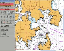
TELchart is an electronic charting system (ECS) for maritime use. The system makes use of vectorized marine charts from C-Map and offers a wide range of functions for navigation, route planning, safety, logging and data presentation.
The TELchart line of products have now been in continual development for more than 16 years, in close cooperation with our partner Furuno Norway's dealer network and end users from fishing, shipping and offshore vessels. In addition, the developers of TELchart themselves have direct experience with marine navigation. This have resulted in a charting system uniquely adapted to user needs while at the same time delivering unsurpassed ease of use.
TELchart maintains its user friendly interface, making the system very easy to learn. At the same time the system can offer a powerful suite of functionality tailored for a wide range of vessel types.
Main Features :
- TELchart makes use of vector-based marine charts from C-Map, and offers a wide specter of options for chart presentation customization for each navigators individual preferences.
- TELchart has taken a long new stride in navigation safety. The vessel movements are continually monitored and analysed in conjunction with the chart data by TELchart anti grounding system.
- AIS is a very useful tool for navigators, both for navigation safety and assistance. TELchart provides to-way communication with most AIS receivers.
- TELchart makes it even easier for fishing vessels to store large amounts of data on their fishing grounds. All symbols, tracks and depth soundings are continually stored so that no data is lost if a power outage should occur.
- TELchart also provides featurs for 2D / 3D ocean floor display (optional). By attaching a depth sounder to the system, the 2D / 3D model is automatically improved . This way, the user can easily generate their own depth charts and improve on the amount of data available from the official chats.
- Close integration with Furuno radars. The radar cursor position can be displayed in the chart, ARPA targets can be displayed in the chart and the route plan can be transmitted to the radar. Radar overlay is also possible (optional).
- Menus and all extraneous information reducing the size of the chart image can quickly be removed and displayed automatically when needed.
- LORAN-C coordinates can be displayed
- Name Search for place names
- SAR (Search and Rescue) search patterns
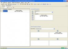
- Target simulation (Dead reckoning)
- Flexible system for sensor data connections, with support for a wide range of equipment
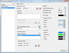
- Powerful and advanced route planning
- Plot cross bearings in the chart
- Replay system allowing playback of data from both own vessel and other ARPA and AIS targets for any previous point in time.


Comments (4)